tour4
Exploring Vermont's Covered Bridges
Condensed from Tour 4: The Lamoille River and the North Branch
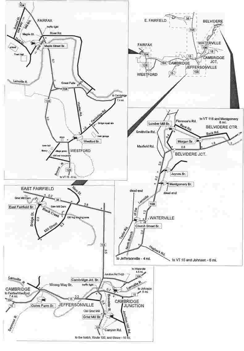
The following presentation was extracted from Chapter Four.It contains part of the tour introduction, the road directions,
a brief description of each bridge, and an updated tour
map based on that published in the book.
The northern Green Mountain watershed feeds an extensive system of rivers and streams with
snow-melt in the spring and with summer and fall rains. The Lamoille River rises in Greensboro
and loops and curls its way roughly seventy miles--as the crow flies--to Lake Champlain. The
North Branch flows into the Lamoille some thirteen miles from its source in Eden. Browns River
curves down from Mount Mansfield and through twenty-two miles of rich bottom land. Black
Creek flows north to the Missisquoi River valley.
People came to these lush valleys starting in the late
1700s, and soon settlements grew, dams rose, mill wheels turned, roads were laid out, and bridges
replaced fords. The towns and villages of Westford, Fairfax, Cambridge, Fairfield, Waterville, and
Belvidere came to be.
Eleven covered bridges remain from the days of
growth in this region. The oldest known surviving bridge dates back to 1838, while the youngest
was completed in 1897. Four are arch bridges, one a plank lattice, and the rest are queen
post.
--From the book; Spanning Time: Vermont's Covered Bridges.

The tour of the Lamoille River and the North
Branch can begin in Westford. There, the 97- foot Burr-truss bridge built in 1838 crosses the
Browns River on Cambridge Road off Route 128. The bridge was rescued from collapse and has
been repaired through the efforts of the Westford Historical Society and the townspeople.
Drive north on Route 128 and Route 104 to Fairfax.
Here a "cross-x" bridge dating from
1865 stands over Mill Brook on Maple Street, a survivor of the 1927 flood. Drive through the
bridge and return to Route 104, then south to Route 15 and the village of Cambridge.
In Cambridge, follow Route 15 north, passing farmer
Gates' corn field and the recently refurbished Gates Farm Bridge, a burr-truss, or "arch" bridge,
originally built by George Washington Holmes in 1897. Continue on Route 15 over the "Wrong
Way Bridge," (which is another story) and proceed to Jeffersonville.
Find Route 108 south toward Stowe and the grist mill.
The 80-foot Grist Mill Bridge, another "arch" bridge, crosses the Brewster River just beyond the
mill.
Retrace Route 108 north to Route 15. Turn right and
drive 0.7 miles to find the left turn to the Poland Bridge in Cambridge Junction. The Poland, a
140-foot "arch" bridge built by G. W. Holmes in 1887 has been closed to traffic.
Return to Route 108 and drive north to Route 36 in
Bakersfield. Turn left and drive three miles east from the intersection to enter East Fairfield
Village. Turn left 0.2 miles past Mill Street. The bridge, a 68-foot queenposter built in 1865 and
open only to foot traffic, crosses Black Creek at the bottom of a small hill.
Return south on Route 108 to the junction of Route
109. Drive north to Waterville to find the Church Street Bridge in the center of the village.
Continue north to the Dallas Montgomery Bridge and the Jaynes Bridge, three covered bridges all
within 2 miles. They are queenpost structures built in the 1870s and 80s.
Drive on north to Belvidere and Mill Bridge Road to
find two more queenpost spans. Cross the Lumber Mill Bridge and then pass through Morgan
Bridge to return to Route 109.
Joe Nelson
P.O Box 267, Jericho, VT 05465-0267
jcnelson@together.net
No part of this web site may be reproduced without the written permission of Joseph C.
Nelson
Text Copyright © 1997, Joseph C. Nelson
Illustrations Copyright ©, 1997, Joseph C. Nelson
This file updated March 13, 2002