We had an excellent spring meeting - one of our best
turnouts - on a fine April day in Waterville. Hope to see
you all there in Windsor at the fall meeting.
Six covered bridge rehabilitation projects are
going on right now: two in Montgomery, one in Fairfield,
Kingsbury in Randolph, Willard in North Hartland, and
soon, the Worrall in Rockingham. Let's get out and observe the progress.
Please plan on voting in the upcoming Bridger
election of officers for 2010 -- we received less than a
handful of responses to the 2009 ballot request.
Beginning with this issue, we have a new
nomination and voting process giving potential candidates an
opportunity to make themselves known to the membership.
Beginning now, and each election year, the summer issue
will ask for candidates for president, vice president,
secretary, and treasurer to serve two-year terms. The candidates
are asked to submit bios to be published in the fall issue
with the ballot. Voters will return the ballots provided in
the fall issue by the published deadline for the winter issue
in which the winners will be announced. The incumbent
officers will serve until midnight, December 31.
Every member in good standing is entitled to
vote. This includes the adult members listed on a Family
membership and the contact person on a Business or Organization/Municipality
membership.
This is an open organization and all members are
encouraged to participate, giving of their time and talent.
If you don't want to run for one of the four offices, volunteer to join
the board of directors by chairing a standing committee or a Bridge-watch
area. The chairmanships for the Historical Committee and many Bridge-watch areas
are open.
Candidates or volunteers will please contact Joe
Nelson, Chairman of the Board of Directors; jcnelson@togeter.net or
PO Box 267, Jericho, VT 05465.
John Weaver, President, VCBS
Return to top
Road trips
By Ray Hitchcock
My wife and I have resumed our tour of Vermont's covered bridges.
We visited 60 of these bridges in southern
and central Vermont over the past three years by motorcycle. Now we
travel to northern Vermont and the pleasures to discover there.
Parent care and health issues slowed down the
process so that only a handful of bridges were visited in
2008. Now a well broken leg has further slowed down the
process. Motorcycles are definitely not the mode of travel
this year, so we are shifting to automobiles.
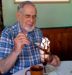 |
| Local Vermonter; photo by Ray H |
While out an about we frequently bump into other
people doing the same thing. One year we ran into a
group visiting from England.
I would surmise that this activity would generate
some good income to local communities throughout the
state. We ran into the interesting fellow in the picture
while doing the bridge tour for the Lamiolle River from
Joe Nelson's book, Spanning Time - Vermont's Covered
Bridges. This "local" was busy helping out the economy
of a Montgomery Center eating establishment.
We were excited to see the progress on the Martin bridge
project just yesterday. The story is covered in this newsletter.
We are always surprised by how dynamic the covered
bridge story is. Bridges just visited a year or two ago
have changed. Mostly for the better! We hope to see you
at one of these great memorials to our history.
Return to top
About that Haupt Truss
by Joe Nelson
The Sayres Bridge, (45-09-06) in Thetford Center,
Vermont, is the only Haupt Truss covered bridge in New
England, said Richard Sanders Allen in his Covered
Bridges of The Northeast, and one of just two in the
United States. At the time of that writing, the other was the
Bunker Hill Bridge (33-18-01) in Catawba County, North
Carolina.
Now, since 1999 there is a third claimant, the
Netcher Covered Bridge, 35-04-63. It crosses Mill Creek
in Jefferson Township, Ashtabula County, Ohio. It was
designed by John Smolen of Smolen-Gulf Bridge fame (35-04-64), 110 feet
long using an "inverted Haupt Truss" with arches
These three covered bridges may have a common
claim in that their builders were inspired by Herman
Haupt's truss design described in his book, General Theory of Bridge
Construction published in 1851, but each of
the three truss systems differ in detail.
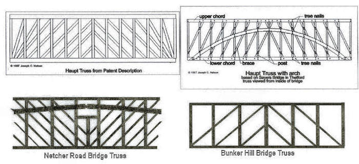
According to his patent letter, Haupt designed his
truss as an improved lattice truss over that patented by
Ithiel Town. Haupt, in his letter to the U. S. Patent Office
(.Specification of Letters Patent No. 1,445, dated December 27, 1839.)
writes, "What I claim as my invention is—The construction of a
lattice bridge without counterbraces,
but consisting simply of braces inclined at any proposed
angle and ties which are perpendicular to the lower chord,
the chords being either straight or curved."
 |
|
Haupt's truss resembles Town's in that both
trusses use planks rather than squared timbers, and the
truss members are fastened with treenails rather than mortise and tenon.
(Netcher uses bolts.) Haupt's patent drawing shows a lattice design in which
the braces (compression members) are sent directly to the lower
chord ends, crossing several panels (see figure), the tension members
here are solely the verticals (ties).
In the Sayres' the compression members interconnect
adjacent panels and cross just one. (See figure.) In the Bunker Hill bridge
truss, the compression members each cross
two panels except the center pair and the end panels.
The truss used in the Netcher Road Bridge inverts
Haupt's truss not only in form, but also in function. Upside
down, Haupt's lattice of compression members and tension
bearing "ties" becomes a lattice of tension members. The
figure depicts the center five panels and a massive double
laminated arch bolted to the ties. The arches, of course, are
compression members.
I contacted Brian McKee in Ohio and asked him what
he knew about the Netcher Road Bridge: "Is this a 'show
bridge' topping on a stringer bridge, or a real working
truss? I don't see how an inverted Haupt Truss could
work." Brian's reply: "The bridge is mainly supported by a
huge laminated arch, not the truss. To call it a Haupt Truss
is not really accurate."
In that Haupt stated in his patent letter ". . . consisting
of braces inclined at any angle . . ." the Sayres and Bunker
Hill trusses are true variants of the Haupt Truss. In the case
of the Netcher Road truss, the lattice is all counterbraces,
contrary to the Haupt design.
Herman Haupt graduated from West Point in 1835.
He resigned his commission to become district superintendent and chief
engineer for the Pennsylvania Railroad.
When the Civil War began he was drafted to serve as superintendent of military
railroads. He pushed his tracks through Virginia, building trestles out of found
materials described by Abraham Lincoln as "bean poles and corn stalks."
[For a full description of the Bunker Hill Bridge and
its truss, go to - JN]
Return to top
About the Williamsville Covered Bridge
[WGN 45-13-05]
by Robert McCullough
The transportation agency will be developing an
interpretive display for the Williamsville Covered Bridge
as part of the reconstruction. Consequently, I've been digging into town records trying to gather as much information as possible. The date of construction and builder remain a mystery, but I've suggested a likely explanation. I'm attaching the material just to pass along the information, for what it's worth. I really need another trip
to Newfane to dig into the handwritten records prior to
1850, but the town clerk's office is in transition and records are in disarray.
Williamsville is situated along the first branch of
the West River, now the Rock River, but for many decades
called simply "the Branch." Both the McClellan Map of
Windham County (1856) and the Beer's Atlas of Windham
County, (1869), identify three bridges in Williamsville.
One crosses the Branch at the village's easterly end, where
a covered bridge stood until destroyed by fire and replaced
by a reinforced-concrete arch bridge in 1908. The second
bridge crosses Baker Brook westerly of the village center
on the road to Dover. The Williamsville Covered Bridge
is the third crossing, also located on the road to Dover a
short distance westerly of the bridge across Baker Brook.
Although the builder and precise date of construction for
the Williamsville Covered Bridge are not known, it was
probably erected no later than 1860.
Newfane's handwritten records of town meetings
and printed annual reports, the latter beginning in 1860,
are inconclusive regarding the date of construction, but
various clues point to the decade of the 1850s. By then,
the improvement of roads leading to and from Williamsville had become a frequent topic at town meetings, possibly the result of periodic flooding. The 1856 McClellan
map shows a mill pond at the site of the Williamsville
Covered Bridge and also an adjacent pail factory. However, that pond and factory do not appear on the Beer's
atlas in 1869. Instead, the Beer's map shows a mill pond
crossed by the bridge at Baker Brook and, at the pond's
outlet, a grist mill. A flood of 1856 did wash away several
buildings and bridges along the Branch, but whether flooding caused the loss of the earlier pond, dam, and factory,
or whether one of the maps is incorrect, is not known.
Another freshet in July, 1859 destroyed nearly every
bridge on Baker Brook,, as well as a saw mill owned by
Dana D. Dickinson and E. P. Wheeler on that same stream.
Written accounts of town meetings up to 1859 do not mention the Williamsville Covered Bridge by that name. In addition, no printed copies of the First Annual Report
(1860) have been found. However, the Second Annual Report
(1861) discloses that L. Halladay received $5.93 for painting
the Williamsville Bridge. Five years later, sometime during
1865 or early 1866, E. P. Wheeler received $5.00 for unspecified
labor on a bridge by that same name. In 1877, the town spent
$113.03 to repair the .Williamsville Bridge. and to apply
new shingles. Twenty years later, 1897 or early 1898, the
town paid L. O. Morse $106.00 to install metal roofing,
again using the name .Williamsville Bridge.. Unfortunately, whether these activities refer to the Williamsville
Covered Bridge or to the covered bridge on the village's
easterly end cannot be verified. Identification of the
builder is also not possible, but timber framers erected a
number of bridges in Williamsville and nearby Pondville
(South Newfane) during these years of road-building, and
the names Daniel O. Stratton, E. P. Wheeler, Dana D.
Dickinson, B. E. Morse, and C. W. Morse appear frequently in town records.
Structural Deficiency
The Williamsville Covered Bridge is located on a
busy Class II road used by heavy emergency vehicles and
school buses, and no convenient alternative routes are located nearby. As originally designed, the bridge's 118-foot
Town lattice truss proved to be inadequate for the weight
of modern emergency vehicles. Many of its timber components were comparatively small when measured against
other bridges of this design and span length. Moreover,
many modifications had been introduced over the years to
strengthen the structure, including numerous sister lattice
planks. At one point, the original timber floor beams had
been replaced with steel I-beams, which were eventually
removed in 1979. That year, the lower five feet of all lattice planks were replaced, but with chords spliced by bolts.
Unfortunately, the modified lattice components lacked sufficient rigidity, creating ere severed from each truss lattice
and replaced with seven-foot segments spliced to the remaining lattice with bolts. Upper and lower bottom chords
were also a systemic weakness in the trusses. By 1998, the
truss lattice and top chords revealed wracking, bowing, and
negative camber, indicating that the entire structure had
begun to fail. As a temporary means for keeping the bridge
open to traffic, engineers installed two very large glulaminated girders inside the structure that year, one on each
side of the single travel lane.
Reconstruction
In 2001, the Vermont Historic Covered Bridge
Committee began discussions about the best method for
preserving the Williamsville Covered Bridge, observing
the guidelines specified by the Vermont Historic Covered
Bridge Preservation Plan. That plan seeks two primary
objectives: (1) to preserve the historic physical and structural integrity of covered bridges to the maximum extent
possible; and (2) to retain covered bridges for use on the
state's network of roads whenever possible, thus preserving the historic functional integrity of these bridges. The
plan establishes priorities for ten preservation treatments,
and the committee must establish that a preferred treatment is not possible before moving to the next recommended treatment.
The Williamsville Covered Bridge is a case study
showing that achieving these worthy objectives can be
very difficult. In its completed form, the bridge is an accurate reconstruction of the original 19th century design,
with only nominal changes to the overall dimensions and
to the size of some chord members. Those changes include glu-laminated lower bottom chords to increase the
bridge's strength, one of several methods of strengthening
considered by the committee.
The preservation plan recommends traditional
methods of strengthening, and the committee initially approved a plan to restore the bridge to its original design,
replacing deteriorated components in kind, and then adding a new, lattice truss to the outside of each existing truss.
The committee recognized the experimental nature of this
proposal but justified its potential compromise to the
bridge's structural and visual integrity, reasoning that engineers would be able to test the way the structure functioned and thus evaluate its applicability at other sites.
However, committee members eventually rejected this
plan due principally to the resulting visual compromises to
the bridge and because so many of the bridge's existing
components would require replacement in any event.
The plan also permits the introduction of large glu-laminated girders as a co-functional, reversible supplemental structural system, reinforcing the existing structure. Two conditions must be satisfied to adopt this treatment: (a) other preferable treatments must be unworkable; and (b) the bridge must be restored to its
original form. The committee investigated the possibility of installing two large glu-laminated girders beneath
the existing structure, thereby satisfying loading requirements. However, the substantial depth of those
beams created poor clearance above the river.
Various other treatments permit the committee to
modify, to a very limited extent, the size of the bridge's
individual structural components in order to achieve the
desired load capacity, specifying that changes to the
bridge's overall dimensions should not occur. Recognizing
that almost all of the bridge's structural components
would require replacement, the committee elected to reconstruct the entire bridge and to modify the original design
only to the extent required to carry emergency vehicles.
The reconstructed bridge standing today differs only
slightlfrom what engineers and historians believe was the
original truss design. The overall bridge width increased
by a total of approximately eight inches and bridge height
(from upper top chords to lower bottom chords) decreased
by two-and-one-half inches. The paired sets of planks,
four each for upper and lower top chords and for upper
bottom chords, were increased in depth by one-half inch.
The sets of four planks for the lower bottom chords were
replaced by sets of two glu-laminated beams, six-and-three-quarters inches by twelve-and-three-eighths inches, one on
each side of the truss web. The dimensions of the original
floor beams are not known, but those installed in 1979, to
replace steel I-beams, measured twelve-inches-by-eighteen
inches set at four-foot intervals, center to center, and may
have been larger than the original floor beams. However,
many of the 1979 floor beams were replaced with glulaminated beams in 1998 when the temporary glulaminated girders were installed. The glu-laminated floor beams used in the reconstruction, ten-and-one-half-inches
by fifteen-and-one-eighth-inches set at four-foot intervals,
are slightly smaller than the floor beams used in 1979. The
lattice planks of the trusses are identical in dimension to
those used in the original design, fifteen-feet by ten-and-three-quarter-inches by three-inches.
[Robert McCullough, of the UVM Dept. of History and member
of the Vtrans Historic Bridge Committee, is Author of Crossings,
A History of Vermont Bridges VAOT & VHS, 2005 - Ed.]
Return to top
Tenth Annual Spring Meeting
of the Vermont Covered Bridge Society
Held at Waterville, Vermont
April 25, 2009
 |
| Spring Meeting 2009, Photo by Bill McKone |
Twenty-four people gathered in the Waterville Town Hall
for the Tenth Annual Spring Meeting of the Vermont Covered Bridge Society.
President John Weaver called the meeting to order at
10:10 a.m. Because the minutes of the Annual Fall Meeting held in Bellows Falls have been published in the Winter edition of The Bridger precedence was followed, in the
interest of saving meeting time, that they not be read. A
vote to accept the minutes as printed in The Bridger was
made by Neil Daniels and seconded by Joe Nelson.
Joe Nelson recommended that the Waterville Historic
Preservation Board, our hosts for the meeting, receive a
copy of each issue of The Bridger.
COMMITTEE REPORTS:
Election: Joe Nelson reports that ballots were to have
been returned by April 1; but to date only three ballots
have been returned. In future balloting will be via The
Bridger. Bios of those running for office will be published in the Summer Bridger. The new procedures will
be explained well in advance in a future issue of The
Bridger.
Lending Library: Warren Tripp reports that any of the
items are available for borrow from the library. He encourages those present to browse and anything can be borrowed as of this meeting. He asks that the borrower's
name and address be provided upon borrowing and the
return be made by US Mail.
Bridge Watch: John Weaver reports there are three rehabilitation projects currently underway: two in Montgomery and one in Fairfield and should be finished up this
year. Three more are planned this yet year: the Kingsbury
Bridge in Randolph, the Willard Bridge in Hartland which
will get a new roof and new railings, plus the Worrall
Bridge in Rockingham which will be significantly rehabilitated.
There are thumb-nail sketches of all of these projects
along with photos on the VCBS web site: vermontbridges.com
Miscellaneous: Joe Nelson reports that Ellen Everitz, Publicity Committee chair, has had a ten-inch column published in the Vermont Magazine.
Treasurer's Report: Neil Daniels reports the following
for the period January 1, 2008 to December 31, 2008:
Total income $3,034.34
Total expense $2,965.58
$68.76
Checking Account at Union Bank 01/01/08 $5,303.30
12/31/08 $5,392.74
Change +$89.44
Save-A-Bridge Fund 01/01/08 $4,372.50
added in 2008 $392.50
Total $4,765.00
(A more detailed cash flow report was submitted and is available if requested).
Membership: Sue Daniels reports that the Waterville area
has the largest representation of members in Vermont of all
of the VCBS membership.
Joe Nelson offers that the VCBS has approximately 200
members residing from New England to the west coast. Of
the total number of members in the Vermont Covered
Bridge Society; only one half are residents of Vermont the
other half are spread across the entire USA and Canada and
.even in Bermuda!.
Neil Daniels and Joe Nelson have been giving their second
round of covered bridge presentations in the Dartmouth
College-sponsored program entitled Institute for Life-long
Learning at Dartmouth. They have had six sessions thus
far.
Old Business: Bill McKone asked if there is an update on
the status of the project regarding coverage bridge signage
along state roads identifying a nearby covered bridge.
Communications on the matter seem to have broken down
with the state legislature.
Archivist Presentation: Bill Carroll, a professional archivist, is now the VCBS Archivist and reports on his efforts
to organize, itemize, and catalogue all of the items that are
currently in the VCBS collection--organized by bridge. So
far Bill has 39 collections itemizing each by an abstract on
each collection dating from the 1930s to present. Bill
hopes to eventually register the collection with the Library
of Congress. New donations are always welcome. The
collection does not circulate as does the library but is available to view upon arrangements with Bill. A permanent
home for the collection is being sought.
Joe Nelson interjects that there are slides from the 1940s to
be added to the inventory.
Warren Tripp mentions that the Vermont Historical Society
has large collection of 8 x 10 archival photographs which
he is in process of photocopying to add to our collection.
There are 17 books of photographs and the bridges are organized by World Guide numbers.
It was mentioned that a lot of the photos of a given bridge
were taken over a period of time so that changes in a
bridge can be noted, i.e. "windows come and go," he said.
Housekeeping: John Weaver mentions that there are
handouts available mapping the covered bridges in the
area for those planning to tour. A list of area restaurants is
also available.
The sales table is set up, thanks to Ruth Nelson, and raffle
tickets will go on sale upon adjournment of the business
meeting. The price is $1.00 each or 6 for $5.00.
Added comment by Neil Daniels, that he mentions
should have been in the Treasurer's report, of the National
Society for the Preservation of Covered Bridges and the
VCBS being mentioned in the will of an elderly lady. The
two organizations were to have been given 5% of the estate. At first look it appeared to be about $8,000; but the
estate was used up because of a $12,000 mortgage. Estate
was eventually less than whole and the Covered Bridge
Societies involved received nothing; but appreciated the
thought.
Bill McKone reports that land at the Cambridge
Junction Bridge is in need of a lease for a near-by park.
The bridge was built at the behest of the Waterville residents for a shortcut to the rail depot to benefit the towns of
Waterville and Cambridge. The freight depot was on a
former rail line between Swanton and St. Johnsbury.
The land of that rail line is now dedicated to recreational use and is being used by VAST (Vermont Association of Snow Travelers) who have leased a 30 foot section of right-of-way. Bill also states that it is hoped for a picnic area near the bridge in the not-to-distant future. A
park-and-ride area already exists.
The Annual Fall meeting of the VCBS will be held in
Windsor, Vermont in the Toll House at the Cornish-Windsor Covered Bridge. Bill Caswell mentions that
there are twenty covered bridges in Vermont and New
Hampshire within a day's drive of that meeting site. The
date for the fall meeting has been set for September 26,
2009. Bill offered to look into having the Fall Meeting as
a kick-off of a two-day tour of those 20 bridges. Skepticism, however, was raised about proceeding with the idea
because the cost of lodging during that fall-foliage season
might discourage bridgers from participating. Suggestions
for the logistics of this tour are welcomed. The tour
would be Saturday, September 26, and Sunday, September
27.
The meeting adjourned at 11:00 by a motion by Sue
Daniels and seconded by Ann Ovitt.
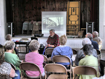
A Power Point presentation and commentary "The Bridges
of Lamoille County" by Joe Nelson concluded the meeting
after which members could tour the covered bridges in the
Waterville/Cambridge area.
Proceeds from the raffle amounted to $67.00
A big THANK YOU is extended to the folks in Waterville for hosting the VCBS meeting at their Town Hall
and to the Waterville Historic Preservation Board for
furnishing refreshments especially Sue Wisehart and
Kathryn Crimby. Also a thank you to the Waterville
Town Clerk, Nancy LaRose.
Respectfully Submitted, Irene R. Barna, Secretary
Return to top

April 1, 2009 - Hello Mr. Nelson, My name is Joe Jewett.
We recently read an article you had written about some
construction repair to one of the covered bridges in Montgomery. I kept your e-mail address and have been waiting
to drop you a line. When I typed in your name, a whole
page of stories came up. In that list is an on-going repair
to the bridge spanning the upper West Hill Branch. My
Dad was born and raised at the top at the hill. His Grand
Father was brother to Sheldon 1852/1889 and Savanard
1848/1925. His name was Bramen 1852/1911. All eight
brothers helped in some capacity during that span in history that the Jewett brothers built bridges. Bramen had 3
children, Bruton, Martin (my fathers name) and Blossom,
all of which have passed on.
We still like to visit the old home site and remaining bridges. We have caught many a brook trout in the swimming hole under that bridge. Sorry I am rattling on.
The reason I contacted you was to inquire if there was any
way to acquire a piece of the original bridge to have as
keep sake. I would love to talk to you more about what
you know about the Jewetts.
Thanks for your time. Look forward to hearing
from you.
Regards, Joe Jewett, West Brattleboro, VT.
[I have put Joe in contact with Jim Ligon, Alpine Construction foreman in charge of the work on Montgomery's
Creamery and Hutchins bridges. Jim is delighted to give
Joe some keepsakes and to meet a Jewett descendent. Joe
should be able get more information about his forbears
through the Montgomery Historical Society - JN]
April 11, 2009 - Good Morning, Joe, by now, we
hope you have had an opportunity to read the various
articles we have written on the creation of the Theodore
Covered Bridge Resource Center. Once completed, it
promises to be a wonderful educational center for anyone interested in researching our Covered
Bridges. Folks will be able to visit the center, relax and
enjoy spending time browsing through books, photographs,
slides, newspaper clippings and newsletters regarding our
bridges. We recently met with the Board of Directors of the
Library and plans are coming along quite nicely. We are
very excited to be a part of this ground breaking project
With that being said, we write today to ask if the Vermont Covered Bridge Society would like to be a part of this endeavor by donating a complete set of your newsletters to
the Center. They would be a wonderful source of information for anyone researching bridges in Vermont.
If you could let us know if the Society is interested in
donating a set of your newsletters, it would assist us not
only in planning for space in the Center, but the construction of bookshelves as well.
Thank you for considering our request. On behalf of the
Theodore Burr Covered Bridge Resource Center,
- Bob and Trish Kane.
[A set of the Bridger newsletter back issues has been
sent to Trish for presentation to the Theodore Burr Covered
Bridge Resource Center, in behalf of the Vermont Covered
Bridge Society - JN]
April 13, 2009 - Dear Mr Nelson, I came across your
name while trying to locate photos and/or articles about a
bridge I'm hoping you may be familiar with the old
wooden truss bridge that crossed over the RR tracks onto
Vine St in Northfield, VT. I realize it is not a covered
bridge, but it is one that has historical and sentimental value
to me.
My grandmother once owned the house that sat at the
end of the bridge (I believe her house was #6 Vine St)
where it first connected to the roadway. I have not been to
Vt in several years and I understand the bridge was torn
down and replaced by a concrete one (yuck!) many years
ago.
I realize your organization is devoted to covered
bridges, but maybe some of your local members may have a
photo of the bridge? Coincidently, while researching this, I
noticed that Northfield is in Washington Co, Vt. and I live
in Washington Co, KY and we ALSO have a covered
bridge in our county. The bridge has been closed for many
years, but is still approachable and able to be photographed
from several angles. I was born in Montpelier and have
family ties to Northfield, though no living relatives are still
in the area.
I would greatly appreciate any help or direction you could
give me in this matter and I look forward to hearing from
you. If it helps, my grandparents were Joseph and Helen
(Marian) Ouellett (Vine St) and John and Winnie Durrell (Cemetery St)
Sincerely, Linda J Klostermann (nee Durrell)
[If anyone has photos or information on this bridge, please contact me, at
jcnelson@together.net, or PO Box 267, Jericho, VT 05465.
I will arrange contact with Ms. Klostermann - JN]
Notice - Covered Bridge Festival - Notice
Hello Trish, Here in Union County Ohio, we are planning
for our 2009 Covered Bridge Festival, which will take
place on September 12, 2009. It will be held in conjunction with Festifair which will be in downtown Marysville
This year's festival is featuring our Spain Creek
Bridge [WGN 35-80-02]. We will have its historical marker presentation in late August.
Anyone who is interested in more info can contact me
at sueipc@jencospeed.net. We would love to see you here.
- Sue Spencer
Return to top
by William Carroll
Windsor, Vt. Toll Bridge
The covered toll bridge, east of the four-corner inter-
section on South Main St., built in 1866, is the longest covered bridge in, or partly in, Vermont, and the only one that
retains the toll gate.
The first bridge on this site was built in 1796, replacing a ferry. It was at this point that [General] Lafayette entered Vermont, on June 28, 1825 for his brief tour of the state.
The records (1811-40) of the earlier toll bridge have
been preserved, though in private hands. On Nov. 12, 1837, for instance, there passed
=General' Lyman Mower with 1 wagon, 1 sulky, 1 horse
and rider, 600 sheep, 127 cattle. The only possible conclusion is that there passed also, toll-free, some dogs. -
Vermont, American Guide Series (ca. 1930s)
Passing of the covered bridge
One by one they are disappearing, the old covered
bridges spanning with their clumsy wooden tunnels the
wide and narrow, slow and fast rivers of pastoral New England.
When the old bridge begins to show signs of decay,
when the roof leaks, broken planks make holes in the solid
sides, and the thick boards below are almost worn away by
the horses' hoofs and the heavy wheels of hundreds of
automobiles, no helping hand is lent to the aging public
servant. It is left to its own fate until it becomes a menace,
and then it is replaced by an iron and concrete successor.
One by one they go, and with them goes much of the
charm of the New England landscape. But memories of
them will linger in the minds of many, memories of their
high pointed roofs between the trees, of their long broad
flanks reflected in the water, of the cool darkness inside, broken by shafts of sunlit dust, of the soft
noise of feet and subdued clatter of hoofs on the worn splintered floor and of the magic
glimpses of the river, the trees and the hills through the opening between the crossing beams or the
holes in the boarded sides.
There was a time when all the bridges crossing the
Connecticut River between the Twin States - Vt. & N.H. -
were wooden covered bridges. Now only a few remain.
Resting squarely and solidly on heavy stone piers, their
elongated tunnels decorated with a latticed stripe on each
side showing the intercrossing of the side beams, they can
boast of real architectural beauty.
The smaller bridges, crossing and re-crossing the rivulets
and brooks of the Green and White Mountain states are quainter, more varied in construction
and appearance, if less beautiful. Resting directly on the two banks, they often look like old
barns placed in this curious position by some strange mistake. -- The Mentor, Aug. 1926
[The above transcription is from a manuscript document,
source unknown, in the VCBS Archives - W.C.]
Return to top
|
by Ellen Everitz
To let people know about the VCBS and the work that it
does I wrote this to various newspapers. VCBS members might also consider posting the follow
ing on the public bulletin board in your community:
"The Vermont Covered Bridge Society (VCBS) is a 501c3
non-profit organization established to promote the preservation of our covered bridges.
Anyone interested is invited to check out our very informative website:
www.vermontbridges.com for many interesting facts
about Vermont's Covered Bridges and the VCBS.
"All are invited to submit their experiences at any
of our covered bridges, including those in their area, such
as unusual occurrences or their impression of them for
inclusion in the VCBS quarterly newsletter. We will also
accept old photographs and postcards, as well as newspaper clippings. All items are to be submitted to: Miss Ellen
Everitz, Publicity Chair, 7 Aspen Drive, Apt. 112, South Burlington, VT 05403-6247, E-mail: calamity99@peoplepc.com."
Here is a very interesting response to the above from a reader:
Dear Ellen,
The Stowe Reporter indicated you are interested
in stories of covered bridges. In 1921 my parents bought
our farm here and I have lived and farmed here since. My
son, his wife and their daughter continue to operate it today. Our water
supply comes from springs located off the property.
Originally the lead pipe from the spring to the
farm was in a hand dug trench. When it reached "Gold
Brook" it was placed in a wood box, covered with sawdust
and the box was hung to the covered bridge.
One morning in the mid 1930's we woke up with
no water running to the farm and house. We soon found
the reason when we discovered the bridge had mysteriously burned in the night.
As far as I know no one to this day knows how
the fire started! I hope this story is helpful.
Merton Pike, Stowe, Vermont
Return to top
by Suzanne Daniels, chair, Membership Committee
Please join me in welcoming the following new members
to our group: Ken & Cathy Blum of Springfield, Vermont, Richard & Gloria Davis of Lakewood, Colorado,
Mark Dawson of Peabody, Massachusetts, John French,
Jr. of West Hartford, Connecticut, and Irene Mele of
Brewster, New York. A warm welcome to each of you!
Upcoming Birthdays and Anniversaries
| June
|
July
|
August
|
| 04 Charlie Elflein
|
04 Neil & Suzanne Daniels
|
03 Joanna Titcomb
|
| 07 Carolyn Clapper
|
05 Bill & Ada Jeffrey
|
05 Joe Nelson
|
| 07 Robert & Barbara McPherson
|
11 Charles & Evelyn Lovastik
|
08 Evelyn Lovastik
|
| 09 Carleton Corby
|
11 Marie Bechard
|
08 Virginia Eckson
|
| 10 Ron & Marie Bechard
|
20 Bob & Trish Kane
|
10 Thomas Carpenter
|
| 14 Dick & June Roy
|
22 June Roy
|
15 Ed Rhodes
|
| 20 Joanne Billie
|
22 Lou Zabbia
|
17 Euclid & Priscilla Farnham
|
| 27 Glen Hall
|
28 Ray Gendron
|
18 Ed & Irene Barna
|
| 27 Terry Shaw
|
28 Dick Roy
|
23 George Conn
|
| 28 Bob Kane
|
28 Jan Lewandoski
|
25 Jim & Linda Crouse
|
| 30 Lionel & Debra Whiston
|
|
25 Leo Fleury
|
|
|
|
29 Ray & Dolores Gendron
|
|
|
|
30 Ada Jeffrey
|
|
|
|
30 Henry Messing
|
|
|
|
30 Robert McPherson
|
|
|
|
31 Kathleen Havranek
|
|
|
|
31 N. David Charkes
|
Return to top
Martin Bridge Back Over River
[WGN 45-12-06]
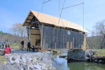 |
Martin Bridge is back
Photo by Joe Nelson, April 29, 2009 |
Marshfield, Vt., April 29, 2009 - The Martin Bridge, after
standing in a field off U.S. Route 2 adjacent to the Winooski River for nearly five years, was returned to its place
over the river this bright spring morning to the cheers of
the watching Marshfield residents.
And cheer they should after a five year effort of raising funds to see this final moment. The bridge will serve as
an entrance for pedestrians to the Marshfield town park.
Happiest of all would be town resident Richard Phillips,
watching his plans come together.
The Martin Bridge was built for William Martin in
1890 by Herman Townsend and his sons. The bridge utilizes a queen post truss and was built to provide access to
Martin's agricultural lands on the far side of the Winooski River.
The Martin Bridge is the only covered bridge remain-
ing in Marshfield and is the only original covered "farm"
bridge left in Vermont. A farm bridge was built solely for
agricultural use. The Martin Bridge and surrounding land
was acquired by the Town of Marshfield in November, 2003.
Before the renovation, because of extensive rotting at
the ends of the bottom chords and the shifting of the abutments, the bridge tilted significantly and was in danger of
complete collapse.
To save the bridge, on May 18, 2004, it was lifted off
its abutments and placed on temporary concrete supports in
an adjacent field. With the bridge out of trouble, local volunteers directed their attention to designing the repairs and to fundraising.
Charles Thorndike, of New Hampton, N.H., gave the
town of Marshfield the 120 acre property, valued at
$87,200, in exchange for the $1,300 he owed in school
taxes. The Selectboard agreed to the deal.
The Martin Bridge, also known as the Orton Bridge,
was in very poor condition and probably would not have
survived many more years without intervention. John
Weaver, PE, Bridge-watch Coordinator for the Vermont
Covered Bridge Society, after reading about the gift of the
Martin Bridge to the town: "Marshfield Makes a Deal", in
the Barre-Montpelier Times Argus, contacted the Marshfield Selectboard and volunteered to evaluate the bridge at
no cost.
Return to top
Montgomery's Creamery Bridge Rehab Paused
[WGN 45-06-09]
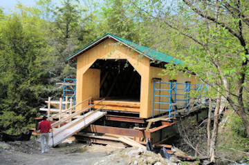 |
Creamery Bridge, West Portal View
May 15,
2009 Photo by Joe Nelson |
Work on the bridge roofing, siding, and superstructure is
complete, abutment and approach work remains to be
done. Work has been suspended waiting for road condtions to allow heavy equipment access to the site.
Alpine Construction, of Schuylerville, New York,
began work on Montgomery's Creamery Bridge on West
Hill in mid September. The Contract completion date is
July 31, 2009. The winning bid was $598,632.30.
Built in 1883 by Savanna and Sheldon Jewett, the
59-foot Town truss bridge spans the West Hill Brook
above a waterfall.
Structural problems forced closure of the bridge in
the summer of 1994. An inspection team recommended
interim rehabilitation to avoid collapse of the structure under its own weight and snow loading. The bridge was
closed with concrete barriers. Over time water washing
down into the bridge from the east end contributed to the
rotting of the floor and floor timbers.
There are two roads leaving the south side of
Route 118 west of Montgomery Village, one at each end
of a cement bridge. One is named West Hill Road and the
other is Hill West Road-perhaps some Yankee humor is
at work here. Creamery Bridge Road joins both roads.
However, the east approach (Hill West Road end) had
been impassable due to wash-out.
Return to top
Hutchins Bridge Reconstruction Progress
WGN 45-06-07
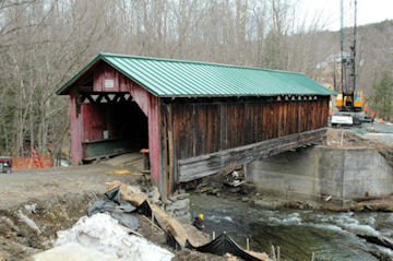 |
| Hutchins Bridge, April 9, 2009, photo by Joe Nelson |
The project began November 2008 and has a completion
date of October 30, 2009. The winning bid was
$1,085,869.93 made by Alpine Construction of Schuyler-
ville, New York. The bid includes a temporary Bailey
bridge.
The abutments for the temporary bridge are ready.
The current activity is preparing the site for work on the
covered bridge superstructure. The bridge will be lifted
above its abutments and suspended by its upper chords on
steel scaffolding.
The 54-foot Hutchins Bridge was built in 1883 by
the Jewett brothers to cross the South Branch of the Trout
River using their usual Town truss.
The Hutchins stands in a quiet valley out of view
of Vermont Route 118. A narrow unpaved road leads to
the portal of the barn-red bridge. It is easy to imagine, in
this isolated spot, that one has returned to the nineteenth
century.
The Agency of Transportation Covered Bridge
Study team inspected the bridge in 1994. The team found
it to be in such poor condition that they recommended
prompt attention to restore its capacity to safely support
traffic. The Agency asked the town to close the bridge
until repairs are performed. Instead, I-beams were installed and the bridge continued in use by the dwelling
beyond.
Return to top
The Hermitage Road Covered Bridge*
 |
| Hermitage Bridge, photo by Anita Rafael |
West Dover, Vermont. March, 2009 - Historic covered
bridges have long been Vermont's most beloved landmarks, so when a traditionally-built covered bridge sud-
denly pops up on the landscape, people far and wide take
notice. The Hermitage Road Covered Bridge at 25 Handle
Road in West Dover, Vermont, is brand new; however, its
vintage style keeps it within the proper historical context
of Windham County's many National Register covered
bridges
The new bridge, which crosses Cold Brook, was
built in 24 days in February, 2009. It is the result of cooperation between the Town of Dover, Vermont and the new
owners of the Hermitage Inn. In 1986, the Town completed a wide concrete span leading from Handle Road
onto Hermitage Road, and with sets of massive bolts to be
used to secure a wooden bridge cover.
It was not until this year, however, that the covered bridge was realized, thanks to the generosity of Jim
and Donna Barnes, owners of the Hermitage Inn. Their
real estate holding corporation funded the entire cost of
the wooden bridge for the Town, including the fees for
permitting, design planning and engineering as well as the
expense of the materials and contractors.
In one sense, the new bridge is already old. It is
built in what is called the "Town Lattice Truss" style, a
construction method dating back to 1820. Ithiel Town
(b.1784-d.1844) of Connecticut popularized the use of
closely spaced diagonal timbers for bridges, even improving on his own engineering and filing new patents again in
1835. Town became wealthy by collecting royalties for
the use of his light, easy-to-build truss system.
In Windham County alone, there are numerous
Town Lattice Truss covered bridges, including five that
are a short drive from the Hermitage Inn: Scott Bridge in
Townshend, Williamsville Bridge in Newfane, Green
River Bridge in Guilford, Creamery Bridge in Brattleboro,
and West Dummerston's covered bridge. The Hermitage
Road Covered Bridge is about to be recognized with a
listing on the 2009 edition of Vermont's popular covered
bridge map and guide.
The timbers in the frame of the Hermitage Road
Covered Bridge are Hemlock, logged in Maine. They are
pegged with custom 1˝" Oak "trunnels." The bridge is
sided with Atlantic White Cedar, which will weather naturally to a silvery gray. The roofing is painted standing-seam steel, a material that is commonly used nowadays
even on historic bridges.
One unusual feature of the Hermitage Road Covered Bridge is that it can be removed in one piece should
major repairs of the bridge's road bed be necessary. By
unbolting the connections holding the wooden cover to the
concrete, it can be lifted off by crane.
During the construction of the wooden cover this
past winter, the road below it remained open to traffic. It
was the one aspect of the project that was particularly
challenging to builder Rob Wadsworth and his 5-man
crew from Vermont Barns in Stratton, the contractors who
built the bridge. After spending one week pre-assembling
two 60 foot-long lattice sides on the snow-covered, they
were able to set the bridge members in place in only one
day using the "barn-raising" method and a large crane.
Once the framework was joined, the contractors added the
roofing and finished the siding and trim over the next two
weeks.
The new covered bridge forms a gateway onto the
100-acre private estate of the Hermitage Inn. Steven
O'Hern, the general manager, expects that since the bridge
is in such a scenic setting, the Inn's guests and passersby
will realize that it is one of the region's most photogenic
landmarks. In autumn, the scenery behind the covered
bridge and along the banks of Cold Brook will be ablaze
in fall foliage; all spring and summer the bridge will be
cocooned by the lush green of the surrounding fields and
forest; and in winter, the snowy white ski slopes of nearby
Haystack Resort will be visible above the roof peak.
[*This article is edited from a press release by
Anita Rafael - Ed.]
Return to top
Williamsville bridge Construction On Hold?
WGN VT-13-05
Newfane, VT, May 14, 2009 - The Vermont Agency of
Transportation informed the Newfane Select board that the
aggressive completion date of November 2009 may not be
met because the contractor may not be able to obtain the
necessary materials in time.
The request for contractors' bids is to be issued this
week. Because of the potential delay, while the contract
will require the completion date to be November, a clause
will be added requiring winning contractor to maintain the
bridge through the winter until the work is completed.
An adjacent land owner will allow construction to on
his property, so the old bridge can remain in use until the
new bridge is ready.
Pomeroy-Academia CB Renovation Completed
WGN PA-34-01
Academia, PA, May 25, 2009 - The Pomeroy-Academia
Covered Bridge Renovation was completed in April; the
Ribbon Cutting ceremony will be held 10 a.m., June 5 at
the bridge between Beale and Spruce Hill townships. For
more information: Visit the Juniata County Historical Society's Web site at: http://www.rootsweb.ancestry.com/
~pajchs/index.html
The Pomeroy-Academia Bridge was closed in 2001
when an inspection discovered rotted beams and termite
and powder post beetle damage. The dismantling of the
bridge began in April 2008. Now, after eight years of
planning, fund raising, and reconstruction, the bridge
will be opened to pedestrian traffic.
The pre-construction money came from fundraisers and a
Keystone Preservation grant of $70,000 from the Pennsylvania Historical and Museum Commission, a Pennsylvania
Department of Economic and Community Development
grant of $34,000 and a loan of $47,000 through the Infrastructure Bank.
Construction costs were funded by TEA 21, or the
Transportation Enhancement Act and from SEDA-Council
of Governments enhancement money, and through the
Pennsylvania Department of Transportation.
The 278-foot Burr Truss bridge was completed in
1903 to cross Tuscarora Creek in 2 spans. It was part of the
Pennsylvania Highway system until 1962 when the state
replaced it with a new span. Slated for demolition, the Juniata County Historical Society took over the bridge.
[Thanks to Tom Walczak for bring this story to our attention - Ed]
Return to top
Bissell Covered Bridge Reopens
WGN MA-06-04#2
Charlemont, MA, May 22, 2009 – After a $3 million, two year renovation, the Bissell Covered Bridge was reopened to motor vehicle traffic this week. The bridge serves Route 8A over Mill Brook.
The Bissell had been supporting only foot traffic since it was bypassed in 1995 by a temporary structure. The 92-foot, two-lane bridge was built in 1951 using a variation of the Long truss to replace an earlier span built in 1840.
The contractor, Palmer-based Northern Construction, dismantled and inspected structural timbers, constructed new abutments; replaced floor beams, deck surface and railings, and installed steel reinforcement rods and a dry sprinkler fire protection system. Built of Douglas fir, 80 to 90 percent of the original "fabric" was retained.
The Bissell, listed on the National Register of Historic Places, is one of five surviving covered bridges in Franklin County listed by the National Society for the Preservation of Covered Bridges publication, The World Guide to Covered Bridges. Two of them, the Burkeville and Smith bridges, were recently restored.
[Our thanks to Caroline Brown for bringing this article to our attention – Ed.]
Dear Readers:
Let us hear from you. What topic do you want our
panel of experts to discuss?
Please send your suggestions to "Trivia", Bob and
Trish Kane, 167 Williams Road, Sherburne, NY 13460, or
bobtrish68@frontier.net - Ed.
Return to top
|
By Suzanne Daniels, Chair, Events Committee
VCBS Meetings in 2009
The Spring Meeting was held in the town hall in
Waterville, Vermont-a community with three covered
bridges! (And two more in neighboring Belvidere!) The
meeting was well attended by approximately thirty people-several from Waterville and the Neighboring towns.
This area is well represented in the VCBS by nine members.
The Historical Society of Waterville provided the
table of refreshments. Joe Nelson gave an illustrated
Power Point lecture on "The Bridges of Lamoille
County."
The Fall Meeting on Saturday, September 26,
2009 is to be held in Windsor, Vermont at the Toll House
for the Windsor-Cornish covered bridge, the longest two-
span covered bridge in the United States
The meeting will be the first time that the Toll
House, located on Bridge Street, on the Connecticut River
and adjacent to the bridge, will be opened to the public.
The circa 1790 cape was the original structure for the toll
collection for the ferry from Cornish, New Hampshire,
across to Windsor in Vermont. Historical structure buffs
will enjoy touring this house.
Return to top
 Joe Nelson, P.O Box 267, Jericho, VT 05465-0267
This file posted 06/13/2009
Joe Nelson, P.O Box 267, Jericho, VT 05465-0267
This file posted 06/13/2009
|
|
|
|
|
 Return to First Page